
Lahsen
A passionate explorer weaving tales of the majestic landscapes and cultural treasures nestled within the rugged beauty of Morocco’s Dades Gorges.
The History of Exploration

In the heart of Morocco, the ancient rocks of Dades Gorges stand in stark contrast to the innovative techniques geologists use to map them. You’ll find that the history of exploration is as layered as the geological features themselves, revealing not just the earth’s past but pointing towards future discoveries. From deciphering rock formations to understanding erosion’s impacts, each step in the mapping process uncovers a piece of the puzzle. The question remains: what secrets do these formations hold about our planet’s history, and how will they shape our understanding of geological processes? This is just the beginning of a journey into the unknown.
Explorers first charted the Dades Gorges in the early 20th century, employing meticulous measurements and advanced geological analysis to map this complex terrain. This initial phase of exploration was marked by the determination of adventurers seeking to understand the Earth’s hidden narratives. You’ll find that their biographies are not just tales of conquest but stories of individuals who bridged cultures and expanded the horizons of knowledge.
These pioneers utilized precise surveying tools and techniques that were revolutionary at the time. They mapped the gorges’ intricate networks of ravines and cliffs, compiling data that would later prove invaluable. Their work didn’t just fill gaps on maps but also laid the groundwork for subsequent scientific research, contributing significantly to our understanding of geological formations.
The cultural impacts of these explorations can’t be overstated. Local communities, previously isolated, found themselves interacting with individuals from vastly different backgrounds. This exchange fostered a unique blend of ideas and customs, enriching both the explorers’ and natives’ perspectives. Moreover, the explorers’ accounts and sketches brought the beauty and complexity of Dades Gorges to a global audience, sparking an interest in the natural world that transcended geographical boundaries.
In essence, the history of exploring Dades Gorges is a testament to human curiosity and resilience. It didn’t just pave the way for scientific breakthroughs; it also facilitated a deeper understanding and appreciation of our planet’s diversity. As you delve into this chapter of exploration, remember that it’s not just about the land that was charted but about the freedom to pursue knowledge and the connections that were forged in the process.
Geological Features Unveiled
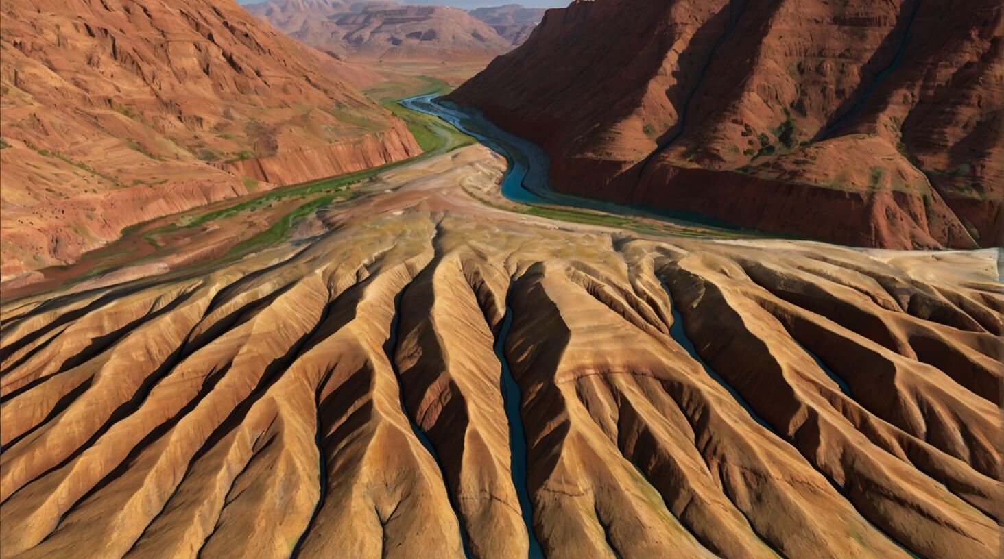
Dades Gorges’ geological structure, characterized by its unique stratification and erosion patterns, offers a vivid illustration of the Earth’s dynamic processes. As you delve into the layers of the gorge, you’ll uncover a rich tapestry of mineral composition that speaks volumes about the region’s geological history. The prevalent minerals, including quartz, feldspar, and various carbonates, have been meticulously cataloged through rigorous sampling and analysis. These minerals, each with their distinct properties, have been shaped and reformed by the relentless forces of nature, painting a complex picture of the gorges’ formation.
Examining the stratification reveals a chronological sequence that spans millions of years, with each layer capturing a snapshot of the Earth’s past environments. This stratification isn’t just a static record; it’s a narrative of the Earth’s relentless evolution, marked by episodes of volcanic activity, sediment deposition, and metamorphism. The precision in the layers’ measurement uncovers a detailed timeline of these geological events, allowing for a deeper understanding of the processes that sculpted the gorges.
Seismic activity, a key driver behind the gorges’ current topography, has played a pivotal role in shaping the landscape. Through the analysis of seismic data, you can trace the fault lines and understand the tectonic forces at play. This seismic activity has not only influenced the gorges’ physical appearance but has also contributed to its mineral diversity. The interplay between seismic forces and the region’s mineralogy highlights the dynamic nature of Earth’s crust, offering invaluable insights into the geological processes that continue to mold the landscape.
As you explore the geological features unveiled in Dades Gorges, you’re granted a unique perspective on the Earth’s dynamic character, where freedom to explore intertwines with the rigor of scientific inquiry.
Techniques in Mapping

To accurately document the intricate details of Dades Gorges’ geological structure, several advanced mapping techniques are employed, leveraging both traditional and cutting-edge technologies. You’ve got the freedom to explore the vast geological diversity of the area, but doing so requires precision and the right tools. Mapping software and satellite imagery stand at the forefront of these techniques, providing a detailed and accurate representation of the terrain.
Here’s a brief overview of the tools and methods involved:
| Technique | Description | Application |
| Satellite Imagery | High-resolution images captured from satellites. | Identifies geological features and structures from a bird’s-eye view. |
| Mapping Software | Advanced software for creating detailed geological maps. | Analyzes and visualizes data gathered from various sources. |
| Ground Penetrating Radar (GPR) | Uses radar pulses to image the subsurface. | Detects and maps subsurface structures. |
| Drone Surveys | Unmanned aerial vehicles equipped with cameras. | Provides detailed topographical data and high-resolution photographs. |
| LiDAR | Light Detection and Ranging technology. | Produces detailed 3D representations of the Earth’s surface. |
Employing these techniques ensures the collection of precise data, enabling you to delve into the complexities of Dades Gorges without physical constraints. Mapping software, in particular, plays a pivotal role in analyzing this data, offering insights that guide further exploration and study. Satellite imagery complements this by providing a comprehensive overview of the area, highlighting features that might require closer examination. Together, these tools embody the analytical approach necessary for detailed geological mapping, offering freedom from traditional limitations and opening new avenues for exploration and discovery.
Rock Formations Deciphered

You’ll uncover the layers of sedimentary rock that have shaped Dades Gorges, analyzing the distinct strata to understand their composition and formation processes. Erosion patterns offer clues to the environmental forces at play, revealing the dynamic history etched into the landscape. Through advanced age estimation techniques, you can accurately date these formations, providing a timeline for their development and the geological events that influenced their current state.
Identifying Sedimentary Layers
In the geological mapping of Dades Gorges, experts meticulously identified various sedimentary layers, revealing a chronological sequence of rock formations spanning millions of years. Through precise layer composition assessments and detailed sediment analysis, they’ve deciphered the area’s geological history. You’ll find that each stratum serves as a page in Earth’s dynamic past, detailing periods of aquatic and terrestrial dominance, climatic shifts, and biological evolution.
Erosion Patterns Unveiled
Building on the foundation of sedimentary layer analysis, we now explore the erosion patterns that have sculpted the rock formations within Dades Gorges. Understanding these patterns unlocks the freedom to predict geological changes and navigate the landscape more effectively.
- Climate Influence: Variations in temperature and precipitation directly impact erosion rates, with higher rainfall accelerating rock decay.
- Vegetation Effects: Root systems can stabilize soil, reducing erosion, whereas areas lacking vegetation exhibit faster rock degradation.
- Water Flow Dynamics: Stream power and seasonal flood events carve through rock layers, shaping the gorges.
- Wind Erosion: Sand and dust carried by wind abrasively wear down exposed surfaces, contributing to the unique formations observed.
These factors collectively dictate the erosion patterns, offering insights into the geological history and future transformations of Dades Gorges.
Age Estimation Techniques
Diving into the age estimation techniques reveals how scientists decode the rock formations’ history in Dades Gorges, employing methods such as radiometric dating and stratigraphic analysis to provide precise measurements of their age. You’ll grasp the meticulous process of unraveling the chronicles embedded within the stone.
| Technique | Description | Application |
| Radiometric Dating | Utilizes decay of radioactive isotopes to date rocks. | Precise age |
| Fossil Correlation | Compares fossils within layers to date them relatively. | Relative dating |
| Stratigraphic Analysis | Analyzes sedimentary layers’ sequence for dating. | Sequence ordering |
These methods, combined with a keen analytical approach, allow for an accurate reconstruction of the geological past, offering you a glimpse into the ancient landscapes that once dominated Dades Gorges.
Erosion and Its Impacts

Erosion significantly alters the landscape of Dades Gorges, reshaping its geological structures through the relentless force of water and wind over millennia. This natural process is accelerated by two main factors: climate change and human activity. Climate change intensifies weather patterns, leading to more extreme rainfall and drought cycles. Human activities, such as deforestation and unsustainable land use, further destabilize the soil, making it more susceptible to erosion.
Here’s how erosion impacts Dades Gorges:
- Reduction of Rock Formations’ Stability: Erosion weakens the base of rock formations, leading to increased instances of rock falls and landslides. This not only alters the gorge’s iconic landscape but also poses risks to nearby communities.
- Sedimentation Patterns Alteration: As erosion progresses, the sedimentation patterns within the riverbeds of Dades Gorges shift. This can lead to the redirection of water flow, affecting both aquatic ecosystems and human settlements dependent on these water sources.
- Soil Nutrient Depletion: The topsoil, which is rich in nutrients essential for plant growth, is the most susceptible to erosion. Its loss leads to a decrease in soil fertility, impacting local agriculture and natural vegetation.
- Increased Water Turbidity: Erosion results in higher amounts of suspended particles in the water, increasing its turbidity. This affects water quality, making it less suitable for drinking, agriculture, and habitat for aquatic life.
Understanding these impacts is crucial for developing effective conservation strategies and ensuring the sustainable management of Dades Gorges’ unique geological heritage.
Biodiversity and Geology

You’ll find that the unique rock formations of Dades Gorges serve as a critical habitat for native species. These geological structures, shaped over millennia, provide not only a refuge but essential resources for biodiversity conservation. Analyzing the interplay between the area’s geology and its ecological dynamics reveals the fundamental role these formations play in supporting local fauna and flora.
Unique Rock Formations
The Dades Gorges feature numerous distinctive rock formations, characterized by their unique biodiversity and complex geological history, including stratified limestone layers and ancient sediment deposits. You’ll discover:
- Color Variations: Ranging from deep reds to pale greys, these hues are indicators of mineral content and environmental conditions during formation periods.
- Climbing Challenges: The diverse topography presents varying degrees of difficulty, appealing to climbers seeking freedom in nature’s playground.
- Stratified Limestone Layers: These formations, often several meters thick, reveal the area’s dynamic geological past.
- Ancient Sediment Deposits: Evidence of water bodies that once covered this land, offering insights into climate shifts over millions of years.
Each element contributes to understanding the gorges’ formation and evolution.
Native Species Habitat
Dades Gorges’ distinctive geological features create a unique ecosystem, hosting a variety of native species adapted to its complex terrain and microclimates. You’ll find that climate adaptation strategies are paramount for these species. Flora and fauna have evolved mechanisms to optimize water usage, critical given the variability of water sources throughout the year. For instance, specific plant species exhibit xerophytic characteristics, allowing them to thrive in arid conditions by minimizing water loss. Similarly, animal species demonstrate behavioral and physiological adaptations, such as nocturnal activity patterns to avoid daytime heat and specialized kidney functions to conserve water. This synergy between geological diversity and biological adaptation underscores the importance of preserving such habitats, highlighting the interconnectedness of geology and biodiversity in Dades Gorges.
Future Research Directions

Exploring the intricate geological formations of Dades Gorges necessitates deploying advanced remote sensing technologies to achieve precise mapping outcomes. You’ll need to dive deeper into the layers of data, discerning patterns and anomalies that were previously unnoticed. This pursuit not only enhances our understanding of the area’s geological fabric but also paves the way for groundbreaking research that could redefine how we approach:
- Climate Adaptation Strategies: By analyzing sediment layers and erosion patterns, you can uncover historical climate events, offering insights into future climate scenarios. This knowledge is crucial for developing robust climate adaptation frameworks, particularly in managing water resources efficiently. Understanding the geological underpinnings aids in predicting flood plains and drought cycles, ensuring water security and sustainability.
- Water Resources Management: The mapping of aquifers and their recharge rates within the gorges will guide the optimal allocation and conservation of water resources. This is essential for maintaining the balance between human needs and ecological preservation.
- Erosion and Sedimentation Control: Precise geological maps can help in identifying areas prone to erosion, enabling the implementation of targeted sedimentation control measures. This is vital for protecting habitats and maintaining the natural flow of rivers and streams.
- Biodiversity Conservation: With detailed geological insights, you can identify unique microhabitats within the gorges, critical for the preservation of native species. This aids in the formulation of conservation strategies that are grounded in the region’s geological reality.
Your role in this endeavor is not just to map out the physical landscape but to unlock the secrets it holds, providing a foundation for sustainable management and conservation efforts.
Related Articles

Geological Significance of Dades Gorges
Hidden within Dades Gorges lies a geological masterpiece, revealing Earth's ancient secrets and inviting explorers to uncover its untold stories.

Dades Gorges Sedimentary Structures
Peek into Earth's ancient past through the mesmerizing sedimentary structures of Dades Gorges, where every layer tells a story yet to be unveiled.

Understanding Dades Gorges Rock Formations
Beyond mere rocks, Dades Gorges' formations hold millennia of stories, inviting an exploration into nature's artistry and the quest for its preservation.